Tuesday, March 27, 2007

Riordan Mansion, Flagstaff

My blog now has a guest book. I would appreciate it if you would let me know you stopped by, by clicking the green link on the right side of the page.
N35.18735 W111.65936


I like touring homes, because of the insights you gain into the character of the home's residents, and the times they lived in. In Flagstaff, the most interesting home to visit is the Riordan Mansion, which was constructed in 1904 for the Riordan families: two brothers and their wives and children. Timothy and Michael Riordan were logging titans; they became millionaires by negotiating 25-year contracts with the railroad to cut down, saw, and sell off the forests of northern Arizona.

Their home--two identical homes, actually, connected by a long playroom--has 40 rooms, over 13,000 square-feet of living area, and servants' quarters. The house is full of original possessions, including a very impressive collection of Craftsman furniture. This style was at the height of popularity a century ago, and still has fans today (including me). It is extremely collectible, with individual pieces known to sell in the hundreds of thousands of dollars.

My favorite item in the home was Tim Riordan's dining room table. It curves like a lens, coming to a point at either end. In this way guests could talk easily with everyone else at the table, and Mr. Riordan could downplay his stature as Flagstaff's richest citizen. The table was designed by Mr. Riordan himself. Mrs. Riordan had a fountain installed close by, which she would turn on to politely remind her husband that he was talking too long.

The main room for family time was called the "swing room." A large green wicker swing hangs from the ceiling, and faced either the fireplace or the trees outside, depending on the time of year.


Sedona, Arizona

Cathedral Rock, just south of Sedona


Mom and I made a day trip to the town of Sedona, about 30 miles south of Flagstaff. The drive there on Hwy 89A passes through the steep and narrow gorge called Oak Creek Canyon. Sedona opens out at the southern end of the canyon,surrounded by beautiful sandstone cliffs and buttes.

Thanks to an elevation drop of about 2,500 feet, temperatures here are much warmer than in Flagstaff. We left snow there, but basked in warmth once we reached Sedona, which lies at the northern fringe of the Sonoran Desert.

Chapel of the Holy Cross, completed 50 years ago
N34.83190 W111.76692


An odd thing about this town is that it is filled with stands claiming to purvey tourist information, but when I asked if any informative brochures might be available, was told that I should go buy a book, because "bookstores sell those kinds of things." Go figure.

Scenery is the main reason to visit Sedona. It also attracts artists and New Age devotees, who believe that Sedona has several "energy vortices." These are locations where Mother Earth supposedly produces invisible, swirling energy that is said to have an uplifting, rejuvenating effect on visitors. Just getting out of town--the traffic was terrible--had a rejuventating effect on me.


Route 66

Flagstaff was on the path of old US Route 66, and the town has gone to some efforts to preserve its memory.

Route 66 began as a way to link main streets of rural and urban communities that had no access to national highways, allowing farmers on the prairies and plains to get grain and other crops to major markets. Its diagonal path from Chicago to Los Angeles is fairly flat and temperate, making it popular and practical for truck shipping. During the Dustbowl of the 1930s, Route 66 was a major route for migrants heading west to California. In the 1950s it was the main highway for vacationers to Los Angeles.

When Route 66 received its numerical designation in 1926 it was the first interstate highway. The entire 2,448-mile length of Route 66 was not paved until 1938. US66 was officially decommissioned in 1985, after it was deemed irrelevant due to the Interstate Highway System. This has crippled many small towns that were economically dependent on the highway.


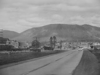
Old Route 66 in Flagstaff: 1950 and Today. Grew from two lanes to five, but seems the weather hasn't changed. (N35.19012 W111.66433)

Flagstaff, Arizona


I love Flagstaff. The elevation is about 7,000 feet; the air is clean; it's near mountains and forest; and the downtown area is nice with several outdoor goods stores. It makes a good base before setting out for the Grand Canyon, which is why I have stayed here twice. Flagstaff got its start in 1882 with the Atlantic and Pacific Railway (later renamed the Atchison, Topeka and Sante Fe). Its early years were centered around forestry and the railroad. Northern Arizona University is here, as well as the Lowell Observatory, where that dearly-departed planet Pluto was discovered.

The weather turned cold here, with an inch of snow on the ground within a day of arrival. And the winds!! Almost makes me kind of homesick for Death Valley. We're staying two nights in Flagstaff, and will make a day trip to Sedona before moving northward.

Monday, March 26, 2007

Hoover Dam


Hoover Dam impounds the Colorado River on the Nevada-Arizona border southeast of Las Vegas. Construction was begun in 1931 and completed in 1936. Over 5,000 workers were employed during construction of the dam, which contains 3.25 million cubic yards of concrete, is 726 feet high, 660 feet thick at the base, and 1244 feet long at the crest. It was the highest dam in the world from 1935 to 1967. Hoover dam generates 4 billion KwH of electricity per year, enough for 1.3 million people.

Lake Mead was created by the Hoover Dam. Water from Lake Mead irrigates farmland in southern California and southwestern Arizona. It supplies municipal water to Las Vegas, Phoenix, and 33 communities in LA area. Lake Mead covers 247 square miles, and has 700 miles of shoreline. It is the largest man-made reservoir in the US.

While the construction of the Hoover Dam was undoubtedly an engineering feat of immense proportions, opinion is split over whether the benefits of the dam outweigh the environmental harm done.

My own opinion (it's my blog, so I guess I'm entitled) is that the benefits are more temporary in nature, while the damage is less so. Population pressures catch up again after a respite of a few decades...look at Las Vegas, which grew phenomenally in the past half-century thanks to the Hoover Dam, but is now constrained again. My thinking is largely influenced by the chapter on the Aswan High Dam in a book I read a few years ago entitled "Something New Under the Sun: an Environmental History of the Twentieth Century World" by historian J.R. McNeill.

Mom and I stopped by here after seeing Susan and Tools off at the Las Vegas airport. We are driving to Flagstaff, Arizona this evening.

Notice how low the waterline is on Lake Mead.


N36.01585 W114.73711

Ghost Town of Rhyolite, Nevada


Left: Rhyolite mercantile, Right: General store


Left: unidentified building, Right: School

Gold was discovered here in 1904, and the town had upwards of 10,000 people within three years. The Panic of 1907 is said to have crippled the town, and the mine closed in 1911. We had a nice picnic lunch next to the old train station.
N36.90083 W116.82919

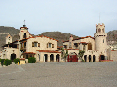
Death Valley Ranch, a.k.a. "Scotty's Castle"


An unfinished hacienda for a Chicago millionaire

Surely one of the most interesting places to visit in Death Valley is "Scotty's Castle," a mansion built by Chicago insurance magnate Albert Johnson between 1922 and 1933. As interesting as the home itself, with its completely original furnishings, is the story of the unlikely friendship between conservative, Cornell-educated Johnson and Walter Scott, a cowboy con artist known to all as "Death Valley Scotty". Don't miss it if you come to Death Valley.

Park staff wear 1930's period costumes when leading tours through the home.


N37.03181 W117.34091

Furnace Creek Ranch (Death Valley National Park)

Furnace Creek Ranch: an oasis at sunset

Much like Egypt, which has been called “the gift of the Nile” so is Furnace Creek the “gift” of underground springs. Almost 2 million gallons per day emerges from a Pleistocene Ice Age aquifer that extends as far east as southern Nevada and Utah.

These springs form the basis for the Valley's large tourism infrastructure, which consumes 95% of the outflow. One of the rangers told me he is concerned that Las Vegas wishes to drill more wells “up aquifer” to serve its growing population, which would reduce the amount of water available to wildlife living in Death Valley.

Furnace Creek was the site of a large Indian village before Anglo occupation of the valley.

The ranch was established to provide food for the workmen and twenty mule teams of the borax mining operations, which eventually became US Borax. Mining operations at Furnace Creek ceased in 1927, and the ranch opened for tourists in 1932. US Borax continued to own the property until 1969. Furnace Creek Ranch has 224 guest units, three restaurants, a saloon, swimming pool, campgrounds, date palm plantation, a borax museum, a 3,040 foot airstrip, and an 18-hole golf course (the world’s lowest).

Coincidentally, just two months ago I stayed with the luge team at the location of the world’s highest golf couse (Sestriere, in the Italian alps). Maybe I should pick up golf again...

Thanks, Susan and Tools!

entrance gate -- the mules have been replaced by tourists

watering the golf course's palms in the early morning

the spring-fed swimming pool is GREAT


N36.45744 W116.86573

Just a Matter of Time

Those of you reading this blog know full well that the time and date shown on the postings are not really when I submitted the posts--I am several days behind with my narrative. An issue that has just gotten more and more confusing to me since leaving California is the simple question, "What time is it?"

When we left there, we drove to Arizona. California is on Pacific Daylight Time. Arizona is on Mountain Standard Time...mostly. That means that even though we changed time zones, I didn't have to change my watch. Yesterday we visited the Hopi Nation, which is on the same time as most of Arizona. But to get there, you have to pass through Navajo country, where they do observe Daylight Savings Time, contrary to the rest of the state. When you leave the Hopi lands, its back into Navajo country--change that watch again! If I had been diligent, I think I should have changed my watch three times yesterday, even though we traveled only 260 miles.

As I write this I am in Kayenta, Arizona, which is near the Utah border. But I'm not really sure what time it is. The sign at the hotel front desk said "Mountain Standard Time (MST)", but a lot of people say that even when they should really be saying "Mountain Daylight Time (MDT)." I think that is the case here.

Add to that, some of my electronic gizmos (like my GPS unit) are not aware that the US moved to Daylight Savings Time earlier this year, and have had to be corrected manually.

What got me onto this topic is that my watch buzzed me awake a short while ago, but the alarm clock has yet to go off...I see they are set to different times. So it's just as well that my posting dates bear no relation to the true time--I probably couldn't tell you if I tried.

Sunday, March 25, 2007

Borax and the Twenty Mule Teams


Of all the minerals mined in Death Valley over the years, borax produced the most profits, and became known as the White Gold of the desert. Borates are salt minerals. They were deposited in ancient lake beds that were uplifted and eroded. Water dissolved the borates and carried them to the Death Valley floor, where they recrystallized as borax. Borax is used in fiberglass, welding flux, insecticides and fungicides, corrugated cardboard, soap and detergents, and fire retardant.

In 1881 borax was found near Furnace Creek. Rights to the claim (and the nearby water, necessary for processing) were sold to William Tell Coleman, who built the Harmony borax works in 1883. Borax was mined at this site until 1888. Chinese workmen gathered the ore.

Site of the Harmony borax works in Death Valley
(N36.47977 W116.87553)

Extracting and processing the borax was a relatively straightforward operation, and the thorniest issue the mining company faced was how to get its product to market. The answer was supplied by the twenty mule team--whose image lives on in Western lore despite being in use only six years (1883-1889)--to haul the ore 165 miles to the railhead in Mojave, California. Its fame is due primarily to a successful advertising campaign which promoted 20-Mule-Team Borax Soap and a long-running radio and television program, “Death Valley Days.”

The twenty mule teams could pull loads weighing up to 36 tons, including 1,200 gallons of drinking water. The entire unit with mules was more than 100 feet long.
In 1884 a steam tractor replaced the twenty mule teams, and this in turn was replaced by the Borate and Daggett railroad. Salt marsh operations such as those at Harmony were obsolete by 1890. The underground Billie Mine, which closed in 2005, was the last borax mining operation in the Death Valley area.

Left: One of the original wagons and water tank for the twenty mule teams. Right: Steam tractor introduced in 1894 to replace the twenty mule teams. It was in turn replaced by the Borate and Daggett Railroad.

Timbisha of Tümpisa

I was somewhat surprised to discover that a tribe of Indians, the Timbisha Shoshone, have lived in Death Valley for centuries, and continue to do so just a quarter-mile from Furnace Creek Ranch. Their name for Death Valley is Tümpisa, which means "rock paint".

The Mesquite tree is a focal point of Timbisha culture. The Timbisha collected fallen mesquite pods, grinding them into a sweet flour and shaping it into cakes to take with them into the mountains when the valley floor grew too hot. These cakes provided food throughout the fall and winter, supplementing a diet of of game and roasted pinenuts. The current health of the mesquite groves is not good, with 95% of the water in Furnace Creek going to support tourist activities.

Relations with outsiders have ebbed and flowed over the years. They were last uprooted from their property in 1936, and their tenure in the Park was guaranteed only recently, when Congress passed the Timbisha Homeland Act of 2000.


Left: Timbisha tribe headquarters. Right: A Timbisha adobe house, built by the CCC in the 1930s.


N36.44985 W116.87387

Mosaic Canyon (Death Valley National Park)


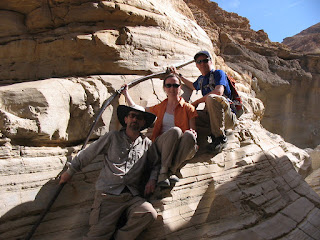
An easy quarter-mile hike leads to the beautiful narrows of Mosaic Canyon, which are composed of smooth, water-polished marble. The canyon drains a 4-square mile area, and could be deadly if a flash flood should occur. The walk has many twists and turns, and an added benefit is that much of it is in the shade.

N36.5684 W117.1386

Charcoal Kilns (Death Valley National Park)


High up (6,875 ft. above sea level) in the piñon pine forest of the Panamint Range, about 10 miles west of Badwater Basin, you can see a collection of old charcoal kilns, designed by Swiss engineers, and built by Chinese laborers in 1879. There are 10 of them, each 25 feet high and 30 feet in diameter.

They suppled the Modock mine smelter, 30 miles to the west, which extracted silver and lead from the ore mined there. After only three years of use, the kilns closed, so that what we see are probably the best preserved charcoal kilns in the West.

Each kiln held four cords of pine wood. Burning the wood took 6-8 days, and cooling the resulting charcoal another 5 days. You can still see stumps of trees felled over a century ago to feed these kilns.

N36.24663 W117.07618

My Take on Death Valley

"Hottest, driest, lowest" are words that quickly arise when describing Death Valley. But for me, it is the middle one which is most shocking. LESS THAN TWO INCHES. That's the average annual rainfall in Death Valley. Water governs everything. To survive and prosper here requires a strategy that conforms to strict parameters set by nature.
Looking down at Badwater Basin, the lowest point in North America (282 ft. below sea level)

Artists Palette


Death Valley, seven miles north of Furnace Creek

Death Valley's modern history goes hand-in-glove with borax. This is the most profitable substance ever mined here (I'll post more on that later), but the era of profitable large-scale mining ended around 1915. Then the managers at United States Borax hit upon an idea. They convinced the National Park Service that Death Valley was a unique national treasure and should be preserved. In 1933 Death Valley was designated a National Monument. This resulted in a temporary closing of lands to prospecting. But by prior agreement, within four months Congress reopened Death Valley to prospecting and mining. Meanwhile, with abundant water, shade trees, and accomodations, Furnace Creek became the heart of a growing tourism industry within the new park. And who owned Furnace Creek? United States Borax, of course.

Where we stayed: Furnace Creek Ranch

Furnace Creek Inn

Death Valley Wildflowers

Panamint Daisy (Enceliopsis covillei)
The majority of this flower's range is within Death Valley.

Although mid-February to mid-April is the peak blooming period, we did not see a great amount of wildflowers in Death Valley during our two-day visit: a few, but not many. The Park Service informed us that a good wildflower year depends on at least three factors: well-spaced rainfall throughout the winter and early spring, sufficient warmth, and lack of drying winds.

Seen in Mosaic Canyon