Thursday, June 7, 2007

End of the Road


After 3,000 miles and 48 postings, the narrative of this journey has come to an end. From here I cross back over the Sierras, smack into the mainstream of California. Within a day I will be back in Oakland.

The American Southwest is a fascinating and rewarding place to visit. You will want to linger...but bring plenty of water.

If you would like to know when Global Safari is updated, just send me an email and I'll keep you in the loop. I continue to welcome your comments and encourage you sign my guestbook. I do not anticipate making any posts, however, until my next trip late this summer. So this blog will temporarily remain--like Bodie, California--in a state of "arrested decay." Thanks for joining me!

Wednesday, June 6, 2007

Bodie, California


Gold was discovered here in 1859, but Bodie's boomtown days were between 1877 and 1881, when over 30 mines were in operation. By 1879 about 10,000 people were living here and there were over 2,000 buildings. The mines here produced gold valued at over $100 million.

The town's reputation for wickedness was second to none; its 65 saloons were notorious. One preacher summed up the town as a "sea of sin, lashed by the tempests of lust and passion." Violence was commonplace, and killings were sometimes almost daily events. "There is some irrestible power," commented the Bodie Standard, "that impels us to cut and shoot each other to pieces." The notorious "bad man from Bodie" became a legend throughout the West. One little girl, whose family was taking her to the infamous and remote town, wrote in her diary: "Goodbye God, I'm going to Bodie."

Bodie lingered on through good times and bad. But in 1932 a fire destroyed 90% of the town, an event which sealed the town's doom. What remains is considered the best all-round ghost town in the West. Its dozens of deep-grained, russet-and-gold wooden buildings are discreetly maintained in a condition of "arrested decay" while weeds grow freely around the many scattered artifacts.

Like the town itself, I will now be silent and let the photos speak for themselves...


Friday, May 25, 2007

Panic at Panum Crater

If I learned one lesson from this trip, it is this:
ON ANY FUTURE CAR TRIP, CARRY A SPARE KEY!

We had already had one lost-key situation in Kayenta, Arizona.
I didn't consider that one to be my fault, so I didn't take the lesson to heart.

Fool!

I had never lost a car key in my entire life. No matter: I had been warned.
Now it was time to pay the price.

Here is how the situation unfolded...

Panum Crater: my date with disaster
N37.93149 W119.04663

(12:30): I decide to visit the Panum Crater near Mono Lake. Only 650 years old, this is the youngest mountain in the youngest mountain range in America, the Mono Craters. Volcanic eruptions began here about 40,000 years ago, and geologists believe they are by no means finished. These are mountains in the very earliest stage of formation.

When Panum erupted (c. 1325-1365 AD), it spewed forth lava with a very high concentration of silica (about 76% quartz), making it very thick and glassy. This lava cooled into several different rock forms: the abrasive stone pumice, and its very-different-looking but chemically identical twin, obsidian.

Obsidian is what attracted me to this place. This is a beautiful black, glassy rock that I have seen in large quantities in only one other place on my--remember, it's "piecemeal"--Global Safari, at Hell's Gate National Park in Kenya.

(12:52): I follow the dirt trail as far as it will take me, and park the car near the bottom of Panum's rim. From there a gently-sloping trail, about six feet wide, leads upward. The trail is "paved" with small pieces of pumice, so it feels like I'm walking on someone's giant landscaping project.

(12:59): I reach the rim, and turn left onto a trail that leads to the center of the crater, what's called the "plug". The rim formed about 1,200 years ago from pumice debris falling back to earth, and the plug (or "dome") dates from the most recent eruption. "NO ROCK COLLECTING," reads a sign along the trail:

On the rim of the crater


Looking from the rim to the dome of the crater, about 500 feet away
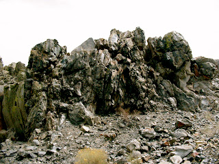

(1:07): Obsidian becomes more abundant the closer I get to the center plug. At first I see it just in small pieces along the trail, then larger rocks, and finally...huge outcrops, taller than a man. The rock is dark, glossy, smooth, sharp and beautiful. No wonder Native Americans used this material for spear points and arrowheads. It is apparently preferred by some surgeons for scalpels even today.

(1:16): Strolling along the path, I see one outcrop after another. Up ahead, off the trail, I notice a couple with a dog that seem to be, yes I think so...collecting rocks. I begin to reason with myself. "Surely," I conclude, "a small sliver or two doesn't harm anything."


(1:20): Having seen what I came to see, I turn and retrace my steps along the pumice path. It is about a third of a mile back to the car. As I come within sight of it, I reach into my pocket...and... (you know what's coming, don't you?)

THE KEY IS MISSING!!

I don't worry at first, because I never seem to place it in the same pocket anyway. So I go through them all. Nothing! Then I empty each pocket in turn, placing the contents on the hood of the RAV4. Still nothing.

(1:25): I finally have to face the awful truth: the car key is somewhere between me and the center of the crater, more than a quarter of a mile away. My water and food are inside the vehicle. I'm miles from any town. Even if I do find it, it will take hours and I'll be very hungry and thirsty. The trail is uneven and dark: the same color as the plastic end of the key itself. But there is nothing I can do except retrace my steps, keeping my eyes on the ground.

"Oh, why? why?" My mind reels in despair. "Why did I ever think I could pick up those rocks? I'm being punished by God!"

(1:27): I start to return up the path, my eyes scanning the ground at every step. The place it is most likely to be, I decide, is near the plug, because that is where the terrain was rougher, where I had stepped off the trail to inspect some rock. As I hurry up towards the rim I pass a young couple that is just arriving here. "I've lost my car key, so if you see one please yell out," I say to them in desperation.

(1:30): I get to the crater rim, less than half the distance I have to cover. I've seen nothing at all yet. I pick up my pace somewhat, in a hurry to get back to the vicinity of the plug. I'm several hundred feet ahead of that couple I passed a few minutes ago, when I hear something... a shout, coming from their direction. It is just a single word...but the most beautiful word I could ever hope to hear:

"TOYOTA?"


By this magnificent stroke of sheer luck, disaster was averted. The husband had seen the key sticking partly out of the pumice rocks on the trail; I had already passed it without seeing a thing.

As close calls go, this one ranks right up there with the time I was locked underground inside the Serapeum of Saqqara. But that's another story...


Am I glad to be leaving here!


Note to readers: With this post, there will be a pause until late next week as I travel back to New York. But please check back then, because there is still more to come! I hope you have a great Memorial Day holiday.

Next: "Goodbye, God. I'm going to Bodie."

Wednesday, May 23, 2007

Mono Lake, California

Have you ever visited someone's house, only to find no answer when you knocked on the front door? Of course you have. Did you go one step further, perhaps going around back to see if anyone was there? And, instead of finding the person you were hoping to meet, you were surprised to find...a yard full of heaps of trash and rusting junk!!

Wouldn't your opinion of that person change somewhat?

Mono Lake
N38.004 W119.011

Well, replace "someone" with the City of Los Angeles, and the "backyard" with Mono Lake. I don't think I can visit that city again without thinking about how it has trashed the ecosystem of Mono Lake, its "backyard" 300 miles away. Mono Lake is nearly 3 million years old. But it has been brought close to the brink of collapse in less than the span of one human life.


Mono Lake is one of the most productive lakes in the West, teeming with plants and animals that have adapted to its salty, alkaline waters. This abundant aquatic life makes it one of the most important wetlands in the entire western hemisphere for migrating and nesting birds.

60,000 California gulls--80% of the state's population--return to Mono Lake every spring and summer to nest and raise their young. Historically, over a million migratory birds, representing 100 different species, used Mono Lake as a stopover point on travels as far-flung as the Arctic and Patagonia.

Mono Lake has a simple food chain. Bacteria provide nutrients for algae, which are eaten by alkali flies and a unique species of brine shrimp that evolved over thousands of years to thrive in the lake's harsh chemistry. The shrimp hatch by the trillions here each year, providing food for millions of birds.

In 1941 the City of Los Angeles extended its aqueduct system into the Mono Basin, diverting water from four of the six mountain streams that feed Mono Lake. As a result, the lake lost more to evaporation than it gained from inflow. Over the next 40 years the lake lost half its volume, doubled in salinity, the surface dropped nearly 50 vertical feet. Miles of newly-exposed lakebottom created dust storms in the windy basin region. The fragile lake ecosystem was given a powerful blow; local wildlife and fisheries, migratory birds and humans all suffered.

A simple food chain is a vulnerable one. As salinity increases, the shrimp and alkali flies become less and less productive. If the environment changes too much or too quickly, the brine shrimp could become extinct. Were that to happen, huge flocks of birds could starve.

As lake levels declined, much wetlands habitat was lost. Without that habitat, the number of migratory birds stopping here has declined greatly.


Tufa towers exposed by the receding surface of the lake.
When freshwater springs rich in calcium bubble up through carbonate-rich lake water, a reaction follows, creating vertical towers of calcium-carbonate deposits called "tufa".

In 1978 a coalition of citizens' groups challenged the legality of the water diversion. Five years later, the California State Supreme Court ruled that there had been a violation of the doctrine of Public Trust, whereby "human and environmental uses of Mono Lake...deserve to be taken into account." In 1990 the court ordered the LA Department of Water and Power to abide by Fish and Game Code laws to protect fisheries in the creeks below the diversion points, and the State Water Resources Control Board began work on a management plan for Mono Lake.

A lake was here, once.
N37.94180 W119.02657

In 1994 the Board decided that the lake must be raised to an elevation of 6,392 feet above sea level, which could take 20 years. This is 19 feet higher than the lake's level in 1994, but still 25 feet below its level when the diversions began in 1941. The next step is to develop and implement a restoration plan for the Basin's streams and wetlands.

Friday: Panic at Panum Crater

Thursday, May 17, 2007

California's Defensive Line

The Sierra Nevada mountains form an unbroken 400-mile-long wall running north to south in eastern California, between the Central Valley to the west and the Basin and Range physiographic province (including the Mojave Desert) to the east.

If you were to approach the Sierra from their western foothills they appear tame, rising gradually over many miles of wooded and well-watered terrain. But if you approach from the east--as I did--be prepared for a shock...the mountains rise abruptly from the valley floor, ascending quickly to heights unattained anywhere else in the contiguous United States. Here on the eastern side, the tameness of the western slope is totally absent. The Sierra Nevada mean business.

I first met the Sierras up close at the town of Lone Pine (N36.604 W118.062). Just west of here Mount Whitney rises 2 miles above the valley floor. At 14,505ft (4,421m) in elevation, this is the highest peak in the Lower 48. Interestingly, it is just 76 miles from Badwater Basin (see my previous post), the lowest point in North America.

Mount Whitney
N36.57959 W118.29250

For the next 185 miles I will be following US Highway 395, running parallel to the eastern slope of the mountains. Along the way there are several signs indicating the passes which lead over to the western side of the Sierras. But all of these are still closed for the winter. The mountains are impenetrable for nearly 200 miles.

The Sierra Nevada at dusk, near Lone Pine, California


The map tells me that I am in the Owens River Valley. Odd, but as I write this post several weeks after being there, I do not once recall seeing the Owens River. Maybe this is because I was driving in the dark evening hours, or... perhaps I arrived a century too late?

The Owens River's natural terminus is Owens Lake, a few miles south of Lone Pine. In existence since the Ice Age, for millenia it was a haven for migratory birds. In historical times it was 10 miles wide, 15 miles long, 30 feet deep. A steamship crossed it. I have to use the past tense, though, because Owens Lake is no more: since 1924 it has been reduced to a dry salt flat which creates noxious alkali dust storms.

The agent of its demise was an aqueduct, completed in 1913, which diverted the Owens River's flow to the city of Los Angeles 250 miles away. The diversion of the river and the disappearance of Owens Lake remain highly controversial, at the heart of the California Water Wars and the subject of a book (which I am currently reading), Cadillac Desert by Marc Reisner.

Further north, not far from the town of Mammoth Lakes is Lake Crowley, a resevoir built in 1941 by the City of Los Angeles. It is named for Father John J. Crowley, a Catholic priest who devoted himself to improving the lives of the residents of the Owens Valley after the diversion of the river drained life from the valley. I will have more to say on this topic in an upcoming post about Mono Lake. So, moving on for now...

Before leaving Oakland, Susan lent me a book describing the many rustic hot springs (露天風呂 "rotenburo" in Japanese) in the eastern Sierras. I decide to visit one called Hilltop Hot Spring, just five miles from Lake Crowley, at about 6AM. It was a little hard to find, but well worth it. The warm water was very soothing and the mountain views were great. Highly recommended!

pipe carrying hot water to the tub

Hilltop Hot Spring, on Alkali Flat in Long Valley.
N37.662 W118.781


Next: Mono Lake

Monday, May 14, 2007

Water in the Valley of Death

Badwater Basin, Death Valley

Today my plans revolve around water. First I want to visit Badwater Basin, the lowest point in North America, and then go for a swim in the spring-fed pool at Furnace Creek Ranch. So, grab your sunscreen, we're on our way...

It has been getting warmer lately in the Mojave, and today (April 3) the temperature rises to 99 degrees here in Death Valley. (Later I checked the weather data, and it was actually hotter here than at any other place in the country that day.) Driving along under the blazing sun I'm thinking to myself, "Why is it so hot here?" Well, this is what I learned from the National Park Service on that topic:

The depth (200+ feet below sea level) and shape of the valley (long and narrow--yet walled in by steep mountain ranges) have a lot to do with it. Clear, dry air and sparse plant cover allow the desert surface to continuously heat up. The heat radiates from the rocks and soil (the ground temperature can be 80°F hotter than the air!) At night, the heated air rises, but is trapped by the high valley walls and comes back down, only slightly cooler than the surrounding hot valley air. Commpression by the low elevation air pressure creates even more heat, so the valley experiences blowing winds of super-heated air.

I reach for the AC.

After traversing Salsberry Pass (3,315ft) and Jubilee Pass (1,290ft), the descent from the southeast into Death Valley proper begins. Signs mark the descent at regular intervals. 600 feet. 200 feet. Sea Level. 100 feet BELOW sea level. It feels like I'm in one of those war movies where the disabled submarine sinks further and further, with gauges moving into red zones and rivets starting to fly from the intense pressure on the hull. My craft finally hits bottom at around 250 feet below the waves. "Status report!" "No damage, sir!" "Restart the engines, maintain 50mph, heading zero degrees!" "Aye aye, captain."

The Panamint Mountains are on my left and the Amargosa Range is to my right. It is very hot. The desert sun is obviously affecting my mind. That last paragraph proves it.

Ahead I see what looks like... snow??

N36.22991 W116.76793


Of course it is not snow; it is salt: sodium chloride, nearly 100% pure. More than 2,000 years ago this area was a lake some 30 feet deep. The water has evaporated, leaving the salt behind in depths of one to five feet.

A briny pond here contains more open water than I have seen anywhere else in Death Valley, but it is four times saltier than the ocean--unfit for man or beast. Hence the name Badwater. But it is not devoid of life. A rare species of snail lives under the salt crust at the edge of the pond, feeding on algae.

Immediately behind the pond rises the steep rock face of the Black Mountains. Estimated to be 1,700 million years old, these Precambrian relics are, I believe, the oldest exposed rocks in the United States. They are remnants of a volcanic mountain belt ancient beyond comprehension, almost twice as old as the surface of the moon.

All very interesting. But I have some less salty water on my mind... I can't wait to make it up to Furnace Creek Ranch, 18 miles to the north, so that I can take a swim in their crystal clear spring-fed pool. I stayed at Furnace Creek Ranch on my previous visit to Death Valley, and it is quite a place! For those of you who might not have read about it, here is the link to my earlier post.

The place to be at the hottest spot in the United States

I spend an hour or so enjoying the cool water and shade of the palm trees. Then I return to the car, looking forward to the next item on my agenda. Now I will drive west out of Death Valley National Park and run smack into the most impressive line of mountains you can see in the Lower 48...the great cordillera of the Sierra Nevada.

"Death Valley is a nice place to visit, but I wouldn't want to buy gas there."
The price of gas in Death Valley on April 3, 2007 was $4.23, 58% above the nationwide average of $2.67

Friday, May 11, 2007

The Old Spanish Trail

The morning begins at 5:30, when I get up to drive Mom to the airport. We've been together for eleven days, through Death Valley, northern Arizona, southern Utah, and now Las Vegas. It's been a great trip. But now she has to return to Iowa, and I must return Susan & Tools' car to them in Oakland.

So now I'm headed west to the Pacific. The first part of this journey, from Las Vegas to Death Valley, will follow an old route called the Old Spanish Trail.

The trail--following ancient paths blazed by Utes, Paiutes and Mojaves--was the primary trade route across the Mojave Desert from the 1820s through the 1850s, extending about 1,200 miles from Santa Fe to Los Angeles.

The Old Spanish Trail was known as "the longest, most arduous and crookedest pack mule route in America"

Back then, trail users included traders, trappers, slavers, horse thieves, military troops and adventurers. Traders took blankets from Santa Fe to California and returned with horses bought and stolen from the west coast. Indian tribes in Utah and Nevada sold their own and other tribal members as slaves in return for European goods.

I picked up the trail heading west on Tropicana Avenue in Las Vegas. Here and there one sees a few references to this historic route.

West Tropicana Avenue in Las Vegas follows the Old Spanish Trail.


On the expanding fringe of Vegas, about 20 miles from the city

Finally, about 20 miles from the fantasy world of the Las Vegas Strip, I put the fastest-growing city in America behind me. Now I'm back in the real world...the Basin & Range, the Mojave Desert.

This was about the only car I saw as I approached the California border.


Downhill from here: Emigrant Pass, 2805 feet above sea level in Inyo County, California
N35.88422 W116.06318

The Lost Forty-Niners passed this way before becoming, well...lost in Death Valley in December 1849. Theirs in an interesting tale of impatience, greed and blunder. Click the link to find out more.

As green as it gets. Near Tecopa, California


At Tecopa I reach Hwy. 127, the north-south road where I take my leave of the Old Spanish Trail. I am about to enter Death Valley National Park, for the second time on this journey.

Next: Bad and Good Water

Wednesday, May 9, 2007

The Strip (Las Vegas: Part 2)

"Ours was the first and will doubtless be the last party of whites to visit this profitless locale." -Lieutanant Joseph Christmas Ives in 1857, on sailing up the Colorado River to a point near the present location of Las Vegas.


A remnant of the old Las Vegas Strip, before things like this muscled in...
N36.12882 W115.16735

The island of Manhattan has been transplanted here, complete with traffic.
N36.10127 W115.17355


In 1970 there were slightly more than 20,000 hotel rooms in Las Vegas. The number today is a staggering 151,000 and rising: another 11,000 are under construction, with a whopping 35,000 more on the drawing board. Vegas already has almost two times the hotel space as New York City. In fact, 15 of the world's 20 largest hotels are found in Las Vegas! The number of tourists has risen from 21 million in 1990, to 39 million in 2006. And they arrive ready to empty their pockets: tourists spent $15 billion here last year, and only 40% of that was in the casinos.

Where is some of that money spent? Let me show you...


Evidence of the secret tradeoff that allowed America to build Euro Disneyland in France


The MGM Grand is the largest hotel in the world with 5,000 rooms.
N36.10228 W115.16948

An exact reproduction of Hofbräuhaus München, with beer brewed in Munich according to the German Purity Law of 1516.
N36.10778 W115.15189


Maybe they have this on their blogs too? Lobby ceiling at the Bellagio.
N36.11307 W115.17631


Left: "The bodies of these birds are comprised of feathers and thousands of fresh Statice flowers. The legs are covered in mixed bird seed."
Right: Somebody should tell the Bellagio about this bug...even fantasy gardens require a good blast of pesticide.


"Well, Edna, that was a bit fancier than back in Des Moines."

Las Vegas Blvd., a.k.a. "The Strip" by night


Video of the hourly fountain show outside the Bellagio.
Does anyone remember we're in the Mojave Desert?

What better way to instill the love of gambling in your children than to combine it with a fairy-tale castle?
N36.09966 W115.17446

End of the day


Next: The Old Spanish Trail